
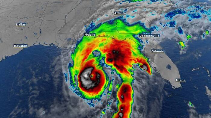
Hurricane Isaias Nears Major Strength, Threatens Florida Panhandle
Hurricane Isaias is nearing major hurricane status and threatens the Florida Panhandle and Southeast with life-threatening storm surge and damaging winds. Residents are urged to prepare for landfall tonight or early Saturday.
Advertisement
Hurricane Isaias strengthened overnight and is on a path to potentially make landfall as a major hurricane near the Alabama-Florida border. Residents across the Florida Panhandle and parts of the Southeast are bracing for life-threatening storm surge, damaging winds, and heavy rainfall as the storm approaches landfall tonight or early Saturday.
As of the latest advisory, Isaias packed maximum sustained winds of 110 mph and tracked north-northeast at 15 mph. Hurricane Hunter aircraft observed stronger winds and a more defined eye, indicating the storm strengthened over warm Gulf of Mexico waters. Forecasters expect Isaias to reach major hurricane status this morning and potentially continue strengthening for several more hours before encountering wind shear that may cause some weakening prior to landfall. It remains forecast to be a dangerous hurricane when it reaches the coast.
A Hurricane Warning is in effect from Ocean Springs, Mississippi, to the Bay/Gulf County line in Florida. A Storm Surge Warning extends from the mouth of the Mississippi River to the Suwannee River. Forecasters predict storm surge of 5 to 7 feet, which could lead to significant coastal flooding. Heavy rainfall is also a major concern, with 4 to 8 inches expected across southern Alabama, the Florida Panhandle, the Big Bend area, and southwest Georgia. Isolated totals could reach up to 15 inches, raising the risk of considerable flash flooding and river flooding. A tornado threat is anticipated to develop late today across coastal Alabama, the Florida Panhandle, and far southwest Georgia, continuing into Saturday across parts of the Southeast.
The National Hurricane Center scheduled its next advisory update for 8 a.m. today, with an updated forecast cone expected at 11 a.m. Residents in the warned areas should monitor official advisories and complete necessary preparations immediately.
Related Topics
Article Ratings
How do you feel about this story?
Megan Harlow
Sign in to follow this author from their profile.



Discussion (0)
Join the Conversation
Join the conversation
Sign in to share your thoughts, reply to readers, and like comments.
No comments yet. Be the first to comment!