
Photo Gallery
Community photos and memories
No photos found.
Community Photos
Photos from local communities and photographers

"lndependence-Courthouse-Missouri.", 1855 - NARA - 513335
Scope and content: Engraving from The United States Illustrated by Charles A. Dana (New York 1855).
Wikimedia Commons (public domain)

4. Santa Fe Trail City Park (2900 S. Santa Fe Road, Independence, MO) on the California, Oregon, and Santa Fe National Historic Trails (2003) (e1a3077e-3680-4611-8f3e-46f619b8d2ee)
ATR-Western Missouri Through Northeastern Kansas-4 Keywords: santa fe trail city park; cali; california national historic trail; oreg; oregon national historic trail; safe; santa fe national historic trail
Wikimedia Commons (public domain)

Confederate Line, Battle of Independence
Confederate battle line during Second Battle of Independence, 1864
Wikimedia Commons (public domain)

Harry S. Truman first day cover 1973-05-08
Harry S. Truman first day cover 1973-05-08
Wikimedia Commons (public domain)

KCPT Transmitter Tower
This image shows the KCPT transmitter tower which is loathed in Independence, MO.
Wikimedia Commons (cc0)

MO - Independence Police
Image of the Independence, Missouri Police Department patch. Made with Photoshop.
Wikimedia Commons (cc0)

Meyers Universum Band 19 22
Independence-Courthouse
Wikimedia Commons (public domain)

Midwest Genealogy Center 1
Midwest Genealogy Center, Independence, Missouri USA
Wikimedia Commons (public domain)

Oregontrail 1907
Wikimedia Commons (public domain)

Railroad Cut, Independence, Missouri
Railroad Cut that featured in the Second Battle of Independence, 1864
Wikimedia Commons (public domain)

The Border War. Another Abolition Outrage. They Try to Run Off Forty Slaves. One of the Jayhawkers Shot, St. Louis Daily Bulletin, December 11, 1860
The Border War. Another Abolition Outrage. They Try to Run Off Forty Slaves. One of the Jayhawkers Shot, St. Louis Daily Bulletin, December 11, 1860. Note: Regarding the shooting of an abolitionist by Morgan Walker near Independence, Mo.
Wikimedia Commons (public domain)

Tree of Peace Society marker Independence Missouri 1999
Descriptive plaque at the foot of an oak tree ceremoniously planted October 24, 1999 by the Tree of Peace Society, a few yards south of Lexington Street in Independence, Missouri, a southwest-curving stretch of Lexington Street which follows the route of the ancient Native-American "Great Osage Trail." The Peace tree is also on the property of the RLDS/Community of Christ "Independence Temple," on real estate claimed and then purchased by Mormon leaders in 1831.
Wikimedia Commons (public domain)
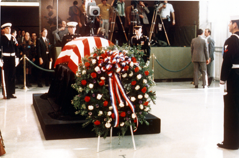
TrumanFuneralWreath
Wreath by US President Harry S. Truman's coffin.
Wikimedia Commons (public domain)

Much of my photography in the past year has been via drone. This was on a June summer evening and taken with my DJI Phantom 3 Pro drone. This is near Railroad Square looking south down Main St.
Much of my photography in the past year has been via drone. This was on a June summer evening and taken with my DJI Phantom 3 Pro drone. This is near Railroad Square looking south down Main St.
Photo by Seth Dewey on Unsplash

Birmingham, AL
Birmingham, AL
Photo by Kalei de Leon on Unsplash

a city street filled with lots of traffic and tall buildings
a city street filled with lots of traffic and tall buildings
Photo by isaac macdonald on Unsplash

landscape photography of vehicles parked on side of a street
landscape photography of vehicles parked on side of a street
Photo by Brandon Jean on Unsplash

a city with many buildings
a city with many buildings
Photo by Nathaniel Villaire on Unsplash