
Photo Gallery
Community photos and memories
No photos found.
Community Photos
Photos from local communities and photographers

Bird's eye view of Great Bend, Kans. - c.s. of Barton County, 1882. LOC 83691189
Available also through the Library of Congress Web site as a raster image. Includes ill. and indexes to points of interest. Acquisitions control no. 2-83 PM3
Wikimedia Commons (public domain)

FEMA - 30224 - FEMA and SBA signs on a FEMA Mobile DRC in operation in Kansas
Great Bend, KS May 27, 2007 - A FEMA Mobile Disaster Recovery Center at the Great Bend High School parking lot. Barton County residents are eligible for assistance due to the tornado/s and heavy rains that have pounded Kansas in recent weeks. Photo by Greg Henshall / FEMA
Wikimedia Commons (public domain)

FEMA - 30225 - FEMA disaster workers prepare signage in Kansas
Great Bend, KS, May 27, 2007 -- Ava Hagen, Manager of FEMA's Mobile Disaster Recovery Center #2, and Disaster Assistance Employee Bob Miller prepare a sign on their first day in Barton County. Central Kansas has multiple disaster declarations due to numerous tornadoes and heavy storms this month. Photo by Greg Henshall / FEMA
Wikimedia Commons (public domain)

General view of Great Bend showing wind mill, implement store, homes, other buildings, from Robert N. Dennis collection of stereoscopic views
Wikimedia Commons (public domain)

General view of Great Bend showing wind mill, implement store, homes, other buildings, from Robert N. Dennis collection of stereoscopic views
Wikimedia Commons (public domain)

Great Bend, Kansas, pictured from the International Space Station (iss073e0509720)
iss073e0509720 (Aug. 18, 2025) --- Great Bend, Kansas, primarily an agricultural town and located at the point where the Arkansas River course shifts, is pictured from the International Space Station as it orbited 261 miles above the Sunflower State. The triangular Great Bend Municipal Airport, once used as a base for the B-29 Superfortress during WWII and now used for general aviation, can also be seen.
Wikimedia Commons (public domain)

Great Bend, Missouri River, at Kansas City - DPLA - c82b1cbae3eaf69a91344733ce773399
Plate: No. 2; On March 9, 1869 a joint resolution of Congress authorizied the changing of the Union Pacific Railway Company, Eastern Division's name to the Kansas Pacific Railway Company.; Although all of the photographs published in Across the Continent on the Kansas Pacific Railyway (Route of the 35th Parallel) are attributed to Gardner, some of the images may have been taken by one of the other photographers Gardner supervised on the expedition. "As official photographer for the expedition,
Wikimedia Commons (public domain)
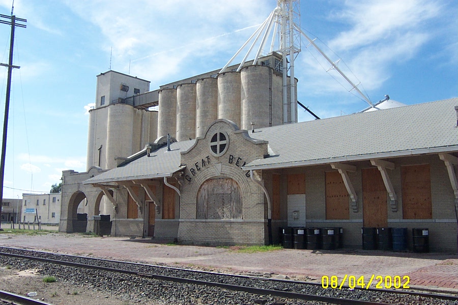
Great Bend Train Station Grain Elevator
Abandoned Atchison, Topeka and Santa Fe Railroad train station and grain elevator in Great Bend, Kansas.
Wikimedia Commons (public domain)

Indians who broke out of their reservation in Indian territory & made a raid across Kan in 1879 & killed settlers near Great Bend & other places. , by Leonard & Martin
Wikimedia Commons (public domain)

Indians who broke out of their reservation in Indian territory & made a raid across Kan in 1879 & killed settlers near Great Bend & other places. , by Leonard & Martin
Wikimedia Commons (public domain)

Wetlands and Wildlife Scenic Byway - Main Street in Downtown Great Bend Kansas - NARA - 7722807
Scope and content: The original finding aid described this photograph as: Original Caption: The fiery reds and oranges of autumn dress the trees along Main Street in downtown Great Bend. Location: Great Bend, Kansas Status: Public domain. Provided by the Great Bend Convention and Visitors Bureau
Wikimedia Commons (public domain)