
Photo Gallery
Community photos and memories
No photos found.
Community Photos
Photos from local communities and photographers
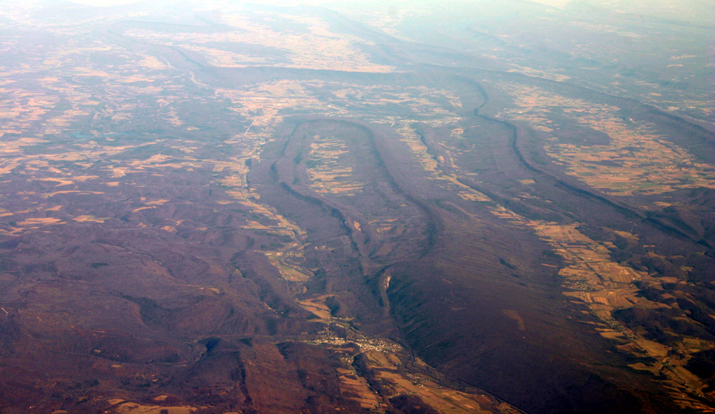
Bedford-co-air
Oblique air photo of central Bedford County, Pennsylvania, facing north. Wills, Evitts, and Tussey Mountains are visible from center to right. Taken Dec. 2006 and uploaded by James Stuby. Contrast enhanced from original photo.
Wikimedia Commons (public domain)

Bedford-co-rt30-warrior
Photomosaic facing north of roadcut along U.S. Route 30 (Everett bypass) through Warrior Ridge, Bedford County, Pennsylvania, showing the lower Devonian sequence from the Keyser Formation and Corriganville-New Creek Limestones at left, to the Mandata Shale, to the Ridgeley Sandstone to the Needmore Shale at right, and Tussey Mountain in background at left. View from same outcrop
Wikimedia Commons (public domain)

Black Valley Branch and Route 326
Looking west on Pennsylvania Route 326 from the Town Creek Road intersection, at Black Valley Gap, in Southampton Township, Bedford County, Pennsylvania, United States. Black Valley Branch is at left.
Wikimedia Commons (public domain)

Chimney rocks
Ritchey Knob from Chimney Rocks; Hollidaysburg, Pennsylvania. Photo by: Joe Calzarette
Wikimedia Commons (public domain)

Harrell Shale outcrop Bedford County PA 2006
Outcrop of Harrell Shale on PA route 4015, Bedford County, Pennsylvania, east of Fishertown.
Wikimedia Commons (cc0)

Herman Point
The high summit is Herman Point (3,034 ft.)a satellite of Blue Knob.
Wikimedia Commons (public domain)

Juniata River meander
Near orthogonal air photo of a prominent meander of the Raystown Branch Juniata River near Breezewood, taken August 2010.
Wikimedia Commons (public domain)

Morrison Cove from Brumbaugh Road
Farm country in Morrison Cove, seen looking eastward from Pennsylvania Route 869 west of New Enterprise in South Woodbury Township, Bedford County, Pennsylvania, United States.
Wikimedia Commons (public domain)

New Enterprise school, built 1928
Northern side and front of the elementary school on Church Street in New Enterprise, Pennsylvania, United States. It was built in 1928.
Wikimedia Commons (public domain)

Overpass on Pennsylvania Turnpike at Bedford narrows, crossing Lincoln Highway U.S. 30 (70275)
Title: Overpass on Pennsylvania Turnpike at Bedford narrows, crossing Lincoln Highway U.S. 30 Subjects: Roads Places: Pennsylvania > Bedford (county) Notes: Title from item. Extent: 1 print (postcard) : linen texture, color ; 3 1/2 x 5 1/2 in. Accession #: 06_10_017940
Wikimedia Commons (public domain)

Overpass on Pennsylvania Turnpike at Bedford narrows, crossing Lincoln Highway U.S. 30 (70279)
Title: Overpass on Pennsylvania Turnpike at Bedford narrows, crossing Lincoln Highway U.S. 30 Subjects: Roads Places: Pennsylvania > Bedford (county) Notes: Title from item. Extent: 1 print (postcard) : linen texture, color ; 3 1/2 x 5 1/2 in. Accession #: 06_10_017944
Wikimedia Commons (public domain)

Raystown Branch of Juniata River in Bedford County 1905
Raystown Branch of Juniata River in Bedford County, Pennsylvania. Probably taken by James Alexander Klahre (1877-1963) in about 1905, from the Pennsylvania Highlands Community College - Klahre Collection. The date and author are based on the appearance of the photo (particularly the style of border) compared with other photos in the collection with known dates.
Wikimedia Commons (public domain)

Ritchey Knob
Ritchey Knob, 2,865 ft., in the Allegheny Mountains of Pennsylvania.
Wikimedia Commons (public domain)

S.S. Grand View Point Service Station (NBY 1768)
S.S. Grand View Point Service Station
Wikimedia Commons (public domain)