
Orlando Summer Storms This Weekend
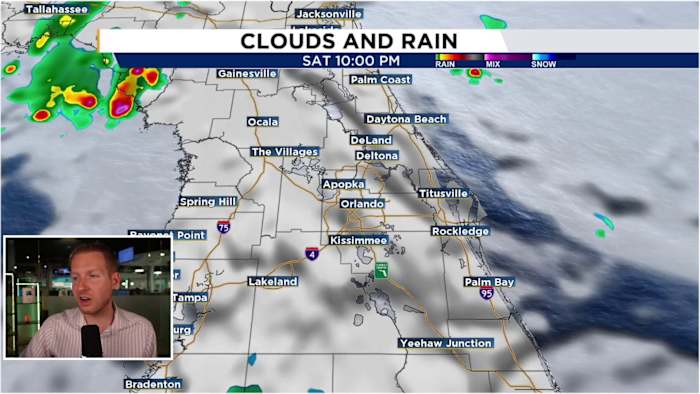
Orlando residents can expect a return of summer-like storm activity this weekend as an upper-level low-pressure system moves into the region. This system will bring increased instability and moisture, generating scattered showers and thunderstorms throughout Saturday and Sunday.
The system began influencing Central Florida on Friday afternoon with spotty, fast-moving downpours, particularly along the I-95 corridor. This trend is forecast to continue Friday evening and overnight, with showers favoring coastal areas.
Saturday, the upper-level low will cross Central Florida, enhancing the sea breeze and its moisture content. Isolated showers are possible along the beaches and offshore Saturday morning. By noon, the developing sea breeze is expected to push showers inland, west of I-95. These scattered storms will move toward the I-4 corridor around 3 p.m. and continue westward, potentially reaching areas near and just east of I-75 by late afternoon. High temperatures are predicted to reach the upper 80s to low 90s.
Sunday's forecast anticipates similar conditions to Saturday, with the upper-level low remaining west of the area. The counterclockwise flow around the low will continue to draw moisture into the region. Residents can expect scattered afternoon sea breeze storms moving from east to west, with high temperatures remaining around 90°F.


Discussion (0)
Join the Conversation
No comments yet. Be the first to comment!